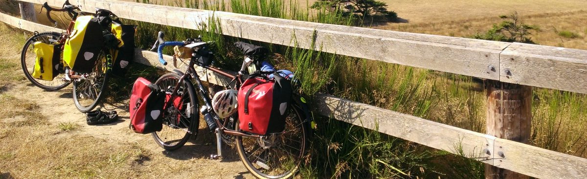
- Day 1: Seattle to Darrington
- Day 2: Darrington to Colonial Creek Campground
- Day 3: Colonial Creek Campground to Winthrop
- Day 4: Winthrop to Alta Lake State Park
- Day 5: Alta Late State Park to Wenatchee
- Day 6: Wenatchee to Lake Easton State Park
- Day 7: Lake Easton State Park to Seattle
Overview
This route is one of the most challenging, with long days and four mountain passes. The scenery, however, is stunning. Whereas coastal routes provide intermittent ocean views, mountain routes offer constant scenic views. This route also takes you to multiple lakes that you can feel free to jump into to cool down.
Speaking of cooling down, this ride is best done during the shoulder season. I made the mistake of going in late July, when the heat was nearly unbearable. I ended up waking up with, or even before, the sun to maximize the amount of riding time before the heat became overwhelming. Riding during the summer also poses the risk of running into wildfires, which could ruin your trip entirely. I recommend doing this trip no later than late June and no earlier than early September, avoiding July and August altogether.
Much of this ride follows the Washington Parks Section 2 Adventure Cycling map. The beginning and end of the route diverge from the Adventure Cycling route in order to turn this ride into a loop that starts and ends in Seattle. Route directions for the sections not covered by the Adventure Cycling map are including in the itineraries for those days. Day 7 follows the Iron Horse Trail, which is very scenic, but unpaved.
Itinerary
Day 1: Seattle to Darrington

Today is a long day of riding that brings you to the true start of the route. You pass through Snohomish and Arlington and end the day in (or near) Darrington.
Distance
Approximately 80 miles, depending on where in Seattle you start and where you decide to camp
Food
Today’s route includes plenty of food options. I had lunch in Snohomish and dinner in Darrington. I might also have had a second lunch outside of Arlington.
Darrington is pretty small, but the Hometown Bakery Cafe is excellent. I recommend checking hours ahead of time to make sure that it is open when you get there. If Hometown Bakery Cafe is closed, you can buy food in Darrington to cook at your campsite.
If you camp at Squire Creek Park & Campground, you won’t reach Darrington before camping, in which case I recommend buying food in Arlington to cook at the campsite.
Camping
You have three options for camping near Darrington; each has pros and cons.
Squire Creek Park & Campground
- Pro: County campgrounds are usually pretty nice.
- Con: As far as I can tell, no showers.
- Con: At times, fully reserved. I couldn’t tell if this campground had any hiker/biker sites, and I couldn’t get a hold of anyone to ask, so I stayed at Cascade Kamloops RV Park.
Cascade Kamloops Trout Farm & RV Park
- Pro: Has showers.
- Pro: When I visited, there were plenty of spaces available, and the campground was not crowded. It also felt pretty safe.
- Pro: The campground is in Darrington, so you have access to services.
- Pro: The tent-only site I stayed in was relatively secluded and pleasant.
- Con: The campground is in Darrington, so you are camping in a town.
- Con: RV parks usually are not my first choice of places to camp.
- Pro: National forest campground in a scenic location.
- Pro: Pretty likely that you can find a campsite.
- Con: No showers.
- Con: A little off-route after a long day of riding.
When I did this trip, I stayed at the Cascade Kamploops Trout Farm & RV Park and had a surprisingly good experience. Were I to do this trip again, I might try the Clear Creek Campground for a more rustic camping environment.
Route
- Burke-Gilman Trail to Sammamish River Trail. Leave trail at Wilmot Gateway Park.
- L Toward NE 175 St
- R NE 175 St.
Becomes NE Woodinville Duvalle Rd - R NE Woodinville Duvalle Rd
- L 156 Ave NE. Becomes 75 Ave SE. Becomes 224 St SE. Becomes Bostian Rd.
- L Paradise Lake Rd
- R Yew Way. Becomes Broadway Ave.
- R Springhetti Rd. Becomes Airport Way. Becomes Ave D.
- R 2nd St.
**Snohomish** 33.2 miles - R Bowen St
- L Centennial Trail
- L 77 Dr NE
- R 162 St NE
- L Centennial Trail
- L 168 St NE
- R 67 Ave NE
- R 172 St NE
- L Centennial Trail
- L 204 St NE/Kent Prairie Rd
- R 67 Ave NE
- R Lebanon St
- L Centennial Trail
- R E 3rd St
- L N Olympic Ave
**Arlington** 23.2 miles Food: The Local Scoop, 434 N Olympic Ave
Food Pavilion, 146 E Haller Ave (1 block N of Burke Ave/530) - R E Division St
- @ traffic circle, 2nd exit: Broadway St
- R WA-530 E/W Burke Ave
**Squire Creek Park** 25.2 miles - R Seeman St
- L Fullerton Ave
- R Darrington St
**Kamloops Park** 28.8 miles
Day 2: Darrington to Colonial Creek Campground
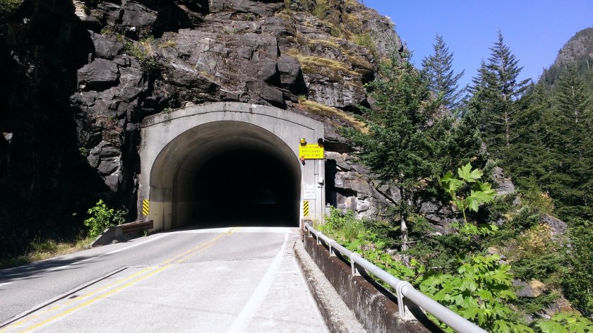
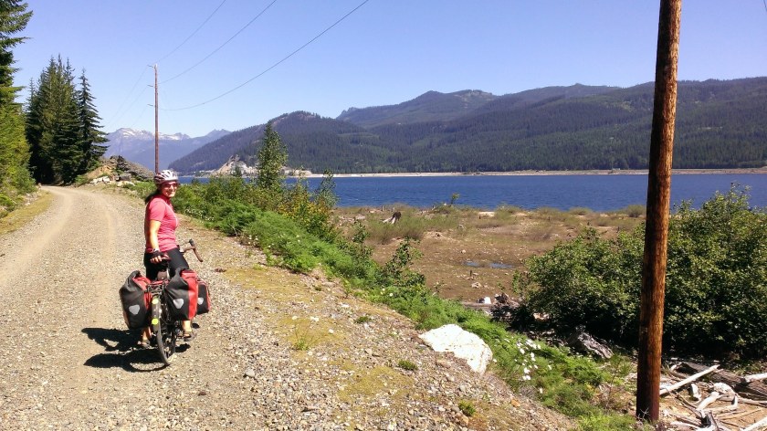
Today you ride the remainder of WA-530 to the intersection with Rockport Cascade Rd, where you connect with the Adventure Cycling route and begin climbing Rainy and Washington passes. The ride is beautiful but tough, with a couple of tunnels thrown in for fun. The tunnels have buttons that you press before entering to alert cars that there are bikes in the tunnel, a great feature of Highway 20 that you should take advantage of.
Distance
Approx. 55 miles
Though the mileage is not high, you spend much of the day climbing.
- 19 miles from Darrington to Rockport Cascade Rd, where you start following the Adventure Cycling route
- 36 miles from the intersection of Highway 530 and Rockport Cascade Rd to Colonial Creek Campground
Food
- In Darrington, you should buy food for at least one lunch and two dinners.
- Lunch: You could stop at the Marblemount Diner for lunch. After that, services are limited until you get to Mazama. If you choose not to stop in Marblemount for lunch, buy food for two lunches and two dinners in Darrington.
- Dinner: Buy food in Darrington to cook at camp.
In Newhalem, you pass a small general store where you can buy some, but not many, supplies. After that, the next place to stock up is the Mazama Store. Bring extra food, though, because there’s always a risk that the Mazama store will be closed when you get there. When I arrived, the power was out and the store was closed.
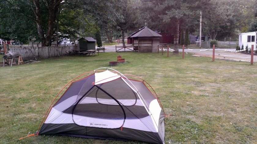
Camping
There are a few campgrounds located shortly before Ross Lake on Highway 20. I chose Colonial Creek campground, because it was the closest campground to the pass. I wanted to get as much climbing in today as possible to make tomorrow easier. Unfortunately, this campground does not have showers. It does have a creek that you can use for a bird bath.
You can stay at one of the other campgrounds near Newhalem, though those locations don’t have showers either, and you would end up riding farther tomorrow.

Route
- From your campsite, rejoin WA-530 and ride north.
- R on Rockport Cascade Rd, where you join the Adventure Cycling route.
- Follow the Washington Parks Section 2 Adventure Cycling map to Colonial Creek campground.
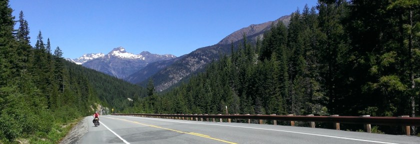
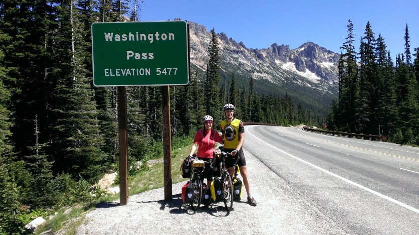
Day 3: Colonial Creek Campground to Winthrop

Prepare for a lot of climbing, and then a lot of downhill. Hopefully you bought food in Darrington, because as you ride through Rainy pass and then Washington pass today, you won’t come across any services until the end of the day (and even then, the Mazama Store might be closed).
Your payoff for a hard day of climbing is arriving in the Methow Valley, one of the most beautiful places in the world.
Distance
You have multiple of options for camping, and the distance you ride today depends on which campground you choose.
- Barn Bicycle Camping: About 55 miles
- Pearrygin Lake State Park: About 67 miles
You can find other places to camp in the area, including a KOA, but these two suggestions seem like the best camping options. If you stay at Pearrygin Lake State Park, you reach your first lake of the trip.
If you prefer to stay indoors, Mazama and Winthrop have great hotels and cabins. The Winthrop Washington website provides more information about places to stay.
Food
- Lunch: Food you bought in Darrington. Be sure to get a lot of food in Darrington, because between the lack of services and the climbing, you’ll get pretty hungry.
- Dinner: If it’s open, the Mazama Store has delicious food. If it isn’t open, you do not come across much food until you get to Winthrop. I recommend bringing enough food for dinner just in case you need it. If you camp at Pearrygin Lake State Park, you are near lots of services in Winthrop. If you camp at the Bicycle Barn, you’ll want to either bring food with you from Darrington or pick up something at the Mazama store.
Route
Continue to follow the Washington Parks Section 2 Adventure Cycling map.
Day 4: Winthrop to Alta Lake State Park

With the most difficult part of the ride over, you can rejoice in the knowledge that you only have two more passes to climb. Luckily, you don’t have to worry about either of them today. Assuming you haven’t made the mistake of doing this trip in the middle of the summer when the heat is nearly unbearable, today should be a beautiful ride through the stunning Methow Valley, passing through Winthrop and Twisp before arriving at Alta Lake State Park, where you get to enjoy a lovely mountain lake.
Distance
Today’s distance depends on where you camped last night.
- Starting from Barn Bicycle Camping: About 50 miles
- Starting from Pearrygin Lake State Park: About 40 miles
Both Pearrygin Lake State Park and Alta Lake State Park are a bit off the main route.
Food
- Breakfast: You could stop in Winthrop to enjoy a coffee in an old west town. The Rockinghorse Bakery is very popular.
- Lunch: The clear choice for lunch is the Glover Street Market in Twisp. I recommend getting the Forbidden Bowl.
- Dinner: In Twisp, buy food for dinner today and lunch tomorrow.
Camping
Not only does Alta Lake State Park have bears, but for a while it had a bionic bear. A bear had been injured in a wildfire and was given a prosthetic paw that it learned to use before being released back into the wild. Unfortunately, the area has had more wildfires since then, and I don’t know the current status of the bear.
Route
Continue to follow the Washington Parks Section 2 Adventure Cycling map.
Day 5: Alta Late State Park to Wenatchee

Today you ride out of the Methow and pass by Lake Chelan before heading to Wenatchee. On route, you pass the Wells Dam in Azwell, where you can see one of the original turbines and learn about how hydroelectric power is generated for the state.
Distance
Approx. 67 miles
Food
- Lunch: Chelan is a quaint tourist town and a well-located lunch spot.
- Dinner: Wenatchee has anything you might need for dinner.
Camping
- Wenatchee Confluence State Park is a quiet park located on a bike trail that takes you to downtown Wenatchee.
- If you want to be further from the city, you could stay at Lincoln Rock State Park or Wenatchee River County Park. Lincoln Rock State Park is a little off-route before Wenatchee, and Wenatchee River County Park is after Wenatchee. If you choose either of those options, plan ahead and bring food for dinner, because you won’t find many services in the immediate vicinity of the parks.
- Wenatchee also has plenty of hotels to choose from if you prefer to stay indoors.
- You could also break today into two days, and camp at Lake Chelan State Park. I don’t see any indication of hiker/biker sites, and the campground fills up, so if you want to stay here, reserve a spot in advance.

Route
Continue to follow the Washington Parks Section 2 Adventure Cycling map.

Day 6: Wenatchee to Lake Easton State Park

You start the day by climbing out of Wenatchee, and then you continue climbing up and over Blewett Pass. Blewett Pass is much gentler than Rainy and Washington passes, and the downhill is more fun, too, because you don’t need to hang on your brakes the entire time. Once you get down Blewett Pass, you diverge from the Adventure Cycling route to head to Cle Elum instead of Ellensburg. In Cle Elum, you join the Iron Horse Trail, also known as the John Wayne Pioneer Trail, and start heading west.
Distance
Approx. 76 miles
- About 50 miles from Wenatchee to WA-970 W, where you leave the Adventure Cycling route.
- About 26 miles to Lake Easton State Park
Food
- Lunch: Leaving Wenatchee, you pass through Cashmere, which is an adorable town and a reasonable option for lunch. Cashmere also has grocery stores if you want to buy something for lunch. If you want to be efficient, you could buy food in Wenatchee to eat for lunch today.
- Dinner: Cle Elum has a fantastic Bar-B-Que restaurant right at the entrance to the Iron Horse Trail, Smokey’s Bar-B-Que. I recommend eating dinner here. The restaurant is not open every day, so be sure to check the schedule. The building that houses the restaurant used to be the Milwaukee Railroad train depot station, and it also contains a railroad museum that has some interesting historical information. You could also buy groceries in Cle Elum and cook at camp.
- In Cle Elum, buy food for tomorrow’s lunch.

Camping
Cle Elum has a number of hotels and inns if you prefer to stay indoors, though since the Iron Horse Inn Bed & Breakfast burned down, none of the remaining options seem very appealing.
Route
- Continue to follow the Washington Parks Section 2 Adventure Cycling map until US 97 S intersects with WA-970 W.
- Continue onto WA-970 W towards Cle Elum
- Continue onto WA-10 W/WA-903 Spur
- L S Cle Elum Way
- R onto the Iron Horse Trail/Milwaukee Rd. Follow the Iron Horse Trail map to Lake Easton State Park.
Day 7: Lake Easton State Park to Seattle
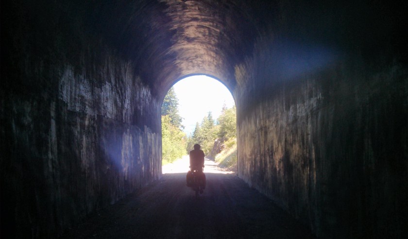
After following the Iron Horse Trail to North Bend, it’s time to finish the loop and head back to Seattle. Though unpaved, the Iron Horse trail is very scenic and has some fun tunnels. Be sure to bring lights. And though the trail takes you over (or under, as the case may be) another pass, you’ll barely notice as you go through Snoqualmie Pass.
After leaving the Iron Horse trail, you follow a handful of local trails, mostly unpaved, back into Seattle.
Distance
Approx. 80 miles, depending on where in Seattle you end the trip.
Food
- Lunch: In Cle Elum, buy food and bring it with you. Until you reach North Bend, you won’t pass many services. The trail keeps you off the road and in the mountains.
- Snack: You might be hungry once you reach North Bend (I was). There’s a nice bakery on the main road. The name should be easy to remember: The North Bend Bakery.
- Dinner: Hopefully by dinner time you’re back in Seattle.
Route
At this point I want to make it clear that if you decided to take a bus back to Seattle from North Bend, that decision would be perfectly reasonable. After North Bend, the route becomes more convoluted and less scenic. Or, if you feel motivated to continue, but not motivated enough to go the whole way, you can catch a bus once you reach Issaquah. The Metro Route 271 goes from Issaquah to the University District and runs pretty regularly.
- Continue following the Iron Horse Trail map until you reach Cedar Falls Rd.
- R Cedar Falls Rd SE
- Continue onto 436th Ave SE
- L SE North Bend Way
- R WA-202 W/N Bend Blvd N/Bendigo Blvd S
- Continue to follow WA-202 W
- L SE Fir St
- R onto Centennial Trail
- L onto Snoqualmie Ridge Trail
- R to stay on the trail
- R Douglas Ave SE
- Turn left at the second street
- R onto SE 78th Pl/Lake Alice Rd SE
- Continue to follow Lake Alice Rd SE
- R to stay on Lake Alice Rd SE
- L onto Preston-Snoqualmie Trail
- R toward Preston-Fall City Rd SE
- L Preston-Fall City Rd SE
- R onto Preston Snoqualmie Trail
- L 300th Ave SE
- R SE High Point Way/Issaquah-Preston Trail
- L onto Issaquah-Preston Trail
- R E Lake Sammamish Pkwy SE
- L SE 56th St
- Continue onto NW Sammamish Rd
- R to say on NW Sammamish Rd
- Continue onto W Lake Sammamish Pkwy SE
- At the traffic circle, take the 1st exit and stay on W Lake Sammamish Pkwy SE
- L onto I-90 Trail/Mountains to Sound Greenway
- R toward SE Eastgate Way
- L SE 37th St
- L150th Ave SE
- R SE 38th St
- Continue onto SE 36th St
- L 128th Ave SE/Factoria Blvd SE
- R onto I-90 Trail. Follow the trail into Seattle.