
Overview
The Selkirk Loop is one of the most beautiful touring routes I’ve done. The trip has great views of lakes and mountains without any actual mountain passes, though the hills get higher and longer once you cross into British Columbia. The best parts of the trip are in British Columbia, so I recommend including the North Kootenay Lake and the Silvery Slocan super side trip.
Technically, this route includes both the North Kootenay Lake and the Silvery Slocan super side trip and the South Lakes super side trip. The latter is only included because I started and ended the trip in Coeur d’Alene, where I could pick up and drop off point-to-point rental cars. The eastern half of the South Lakes super side trip was reasonably nice, but the western half takes you on busy roads. You might want to think about other places you could start and end the loop, like Nelson, B.C. or Sandpoint, ID, though car rental options are more limited in those locations.
As often as possible, I tried to find nice campsites. In some locations, the only campgrounds available (or the only campgrounds available with showers) were at RV parks, which weren’t very nice. Due to my riding partner breaking spokes far from any bike shops, we spent the last night in a motel instead of a campground, and the last day of riding turned into a very long taxi ride.
This region can get really hot in the summer, so I recommend doing this trip during the shoulder season, May/June or September/October. I did the trip in mid-June, and the temperature was perfect, plus I had the advantage of extra daylight.
Maps & Routes
I used the Selkirk Loop Cyclist’s Guide for most of this trip. As someone used to the Adventure Cycling route maps, this map was a bit disappointing. It doesn’t provide much information beyond which road to take, and even then, they recommend that you follow the secondary routes in many places. Where applicable, I followed all the secondary routes on my trip. On Day 7, I followed the Adventure Cycling Northern Tier Section 1 route from Ione to Newport.
More information about the ride, including 5- and 10-day itineraries, can be found on the International Selkirk Loop’s Road Cycling page. You can also browse an interactive version of their map on the Bicycling Map page.
Itinerary
Day 1: Coeur d’Alene to Farragut State Park
After driving to Coeur d’Alene, I immediately rode about 23 miles to Farragut State Park. This portion of the ride is nothing special (unless you consider learning how close you are to an amusement park special, which I do), but the ride north from Coeur d’Alene was pretty easy, and the campground was beautiful and had showers.
Distance
Approx. 23 miles
Logistics
Driving
I picked up a point-to-point rental car from Enterprise Rent-A-Car in Seattle and dropped it off at the office in Coeur d’Alene. I arrived early enough that biking 23 miles to a campground was no problem at all.
Food
Cook dinner in camp. Either bring food with you for this, or pick some up in Coeur d’Alene before heading out.
Camping
I reserved a campsite in advance, because I couldn’t find any information online about hiker/biker spots. I didn’t see any hiker/biker spots when I arrived, either, though the campground is pretty large. Being able to bike right to a pre-reserved spot and know that I would have power and water on-site was nice enough that I recommend reserving in advance.
Route
I started the ride at the Enterprise Rent-A-Car office in Coeur d’Alene. Wherever you start, you want to get to US-95 N, which, if I recall correctly, has a bike lane running alongside it.
- North on US-95 N
- R E Garwood Rd
- L N Pope Rd
- Continue straight onto E Homestead Loop
- R E Bunco Rd
- L N Bunco Rd (curves right and becomes E Bunco Rd again)
- L N Lewellen Creek Rd
- R E Old Railroad Grade Rd/E Whitetail Dr
- L N Good Hope Rd
- At the traffic circle, 1st exit onto ID-54 E
Day 2: Farragut State Park to Bonners Ferry
Staying in Bonners Ferry makes me really wish I could stay in Sandpoint instead. The ride this day goes on some busy roads, and you spend quite a bit of time riding on a trail right next to the highway. It never felt unsafe, but it was often unpleasant. Sandpoint is very cute, though, and a great place to stop for lunch.
Distance
Approx. 60 miles
Food
Sandpoint has lots of great lunch options. Just decide what you’re in the mood for, and pick a restaurant accordingly.
Bonners Ferry has limited food options. If you want to eat out, the obvious choice is Kootenai River Brewing Co. Bear in mind that this is a small restaurant in a small town, and service might not be fast. They have a great outdoor patio, though, and the food and drinks were lovely. Just be patient with and kind to the server, unlike the guy at the table next to us.
Camping/Lodging
There is one place to camp in Bonners Ferry. If you feel the need to camp, you can camp at the Carriage House Inn & RV Park. It’s safe, close to a grocery store, and has showers. There’s really nothing else I can say to recommend it. The bike camping is basically in the backyard of the family who owns the RV Park, and I very much felt like I was camping in a stranger’s backyard, and a loud stranger at that. It was uncomfortable enough that I decided it was worth walking into town for dinner instead of cooking at the campsite.
A better option is to stay at the Northside School B&B. Because I didn’t stay there myself, I don’t have much to say about it. Some friends stayed there, though, and they said the rooms were reasonably nice and the breakfasts were very large.
Route
I followed the Bayview to Sandpoint section of the Bicycling Map to Sandpoint, and then followed the secondary route directions north from Sandpoint into Bonner’s Ferry.
Day 3: Bonners Ferry to Lockhart Beach Provincial Park
The ride gets significantly better once you leave Bonners Ferry. There’s some lovely riding along the river, a gravel section that’s great or annoying depending on how you feel about riding on gravel, and then everything gets quieter and bigger as you head towards British Columbia.
The gravel section outside of Bonners Ferry is longer than the route directions indicate. I think it was between five and six miles, and though the scenery is beautiful, the gravel gets pretty rough. Be prepared.
Once you get into British Columbia, campgrounds get a bit sparser. Nevertheless, they’re somewhat regularly spaced and well-maintained.
Distance
Approx. 73 miles
Food
Creston is a great place to get lunch and pick up supplies for dinner. I ate lunch at the Golden Flower Bakery, but it’s hard to go wrong with restaurants once you get to British Columbia, where all food is better.
I also stopped at the grocery store and picked up food to cook for dinner.

Camping/Lodging
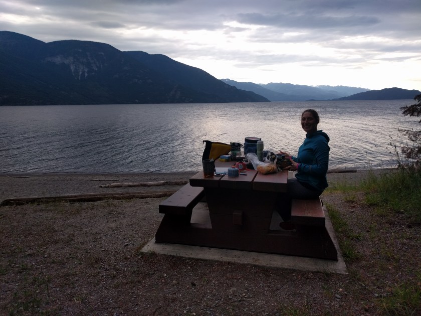
Lockhart Beach Provincial Park *no showers*
These campsites are non-reservable, but if you arrive on a weeknight or even early on a weekend, it seems unlikely that you would have any trouble getting a spot. Though there are no showers, there is a lake that you can swim in.
Route
I followed the secondary route directions north from Bonner’s Ferry. Note that the route directions specify 4.2 miles of unpaved trail. The trail is definitely longer than that, possibly as much as 6 miles, and in places, the gravel is pretty rough. Still, that route seems preferable to riding on the highway. Also, parts of the route are very scenic.
Also make sure to follow the secondary route directions into Creston. Creston could be easy to miss, and that would be a shame, because it’s the last real city of the day and a good place to pick up supplies.
After Creston, follow the Creston to Boswell section of the Bicycling Map.
Day 4: Lockhart Beach Provincial Park to New Denver
This was my favorite day of the trip. You go through Crawford Bay early in the day, which is a really lovely artist town. I recommend taking some time to stop at North Woven Broom Co. Then you take a gorgeous ferry ride across Kootenay Lake before biking to Kaslo. Kaslo is a great town, and a good place to stop for lunch before biking over the only pass of the trip.
The ride from Kaslo to New Denver was my favorite ride of the trip. Though it technically crosses a pass, the incline is much gentler than most of the other hills in the British Columbia portion of the trip, so it ends up being relatively easy.
I did not stop at the Ainsworth Hot Springs, but I have heard that they are incredible. If you have an extra day, this might be a good time to have a short riding day and treat yourself to a resort.
In New Denver, you might want to stop at the Nikkei Internment Memorial Centre, which is close to the municipal campground. It closes at 5pm and doesn’t open again until 10am, so you should plan your day in advance if you want to arrive in time.
Distance
Approx. 72 miles
Food
Kaslo is a great place to get lunch and pick up supplies for dinner, as long as you have enough snacks to get through the morning. For lunch, I bought a sandwich and snacks at Eric’s Meat Market and Deli and ate in one of the town’s parks.
I also stopped at the grocery store and picked up food to cook for dinner. Though you can also buy food in New Denver, by the time I arrived, most stores had closed.
Camping/Lodging
Centennial Park Campground in New Denver
If you prefer to split this day into two shorter days, you could spend one night at the Kaslo Municipal Campground before biking to New Denver.
The Centennial Park campground only accepts cash, and the showers take Loonies. Be sure to get some Canadian money before you arrive. Normally I wouldn’t recommend campgrounds so close to cities, but New Denver and Kaslo are very nice and small, and the campground was safe, clean, and really beautiful. I also met lots of friendly people who told me more about the area.
If you prefer to stay somewhere more remote, you could stay at the Rosebery Provincial Park. It does not have showers.
You could also have a short day of riding and spend a night at the Ainsworth Hot Springs, which get rave reviews.
Route
Follow the Bicycling Map.
Day 5: New Denver to Nelson
This might be my second favorite day of the trip. The scenery is absolutely beautiful, and you pass through some interesting small towns. Nelson is one of the few places on this route that has a bike shop, so keep that in mind when you get to town.
I stayed at an inn in Nelson, with the rationale that in a city this size, the municipal campground might not be as pleasant as the campgrounds in the smaller towns. There is a provincial park about ten miles outside of Nelson that you can stay at if you plan well. If you want to stay at a hotel or inn, I recommend making reservations in advance.
Distance
Approx. 70 miles
Food
There are a few scattered places where you can get lunch along the route, but you might want to have some extra food just in case. Some parts of this route feel pretty remote.
If you stay in Nelson, you have unlimited dinner options. If you decide to stay at the provincial park outside of town, pick up groceries in Nelson to cook at the campsite.
Camping/Lodging
I stayed at the Cloudside Hotel, which was lovely, centrally located, and had a shed for bikes in the back of the property. They also upgraded my room because of booking logistics, so I had plenty of space to spread out.
Nelson does have a municipal campground, but I have generally had bad experiences staying in campgrounds this close to cities. If you are willing to have a longer couple of days, you could camp at the Kookanee Creek Provincial Park.
Route
Follow the Bicycling Map. It might seem tempting to take the Great Northern Rail Trail from Nelson to Salmo, and if you love gravelly dirt trails, you might enjoy this. I tried taking this trail, had an incredibly difficult time getting out of Nelson, because they were actively cutting down trees the day I went through, and then the trail became unrideable by my standards. I recommend staying on the road.
Day 6: Nelson to Ione
About 20 miles outside Nelson, my riding partner broke a spoke. The good news is that you can ride with a broken spoke. The bad news is that unless we turned around, there was no bike shop until the end of the trip. And the risk of riding with a broken spoke is that more spokes will break, and eventually you won’t be able to ride. We had to make a choice, and we chose to continue riding south.
We decided, though, that rather than camping at one of the semi-remote Sullivan Lake campgrounds across the river from Metaline Falls and Ione, we would stay at the motel in Ione. As I recall, the scenery on this ride was lovely; it was just tinged with the stress of worrying about broken spokes.
Distance
Approx. 62 miles
Food
There are some small towns between Nelson and the border where you can pick up lunch. The towns are very small, though, and you could easily miss them. I had lunch in Ymir, which is slightly off-route but worth the detour. You could also eat in Salmo. If you decide not to go through Metaline Falls and Ione, you should pick up food in Salmo for dinner this night and lunch the next day.
If you decide to camp, pick up food in Salmo or Metaline Falls before leaving the mapped route to head to a campground.
If you decide to stay in Ione, there are not many restaurant options. I bought food at the grocery store and ate it on the motel’s patio, which overlooked the river. It was a very pleasant evening.
Camping/Lodging
I had a really good experience at the Riverview Motel. It was clean and the owners were friendly. They had recently added a patio with tables and a grill overlooking the river, which is where I ate dinner. They also have laundry machines and are close to the grocery store.
If you prefer to camp, you can take a bit of a detour to Sullivan Lake, which has three campgrounds: East Sullivan campground, West Sullivan campground, and Noisy Creek campground. These are all USDA Forest Service campgrounds, and none have showers. My original plan had been to camp at Noisy Creek campground.
Full disclosure: There is an RV park in Ione where you can camp. It has showers. But after my RV park experience in Bonners Ferry, I felt highly skeptical of RV park camping. As we biked past it, I looked over at it and thought, “Not again.” But it might be completely fine and not at all sad. It certainly looks better than the Bonners Ferry RV park. If you want to give it a shot, it’s the Cedar RV Park.
Route
Follow the Bicycling Map.
If you decide to camp at one of the Sullivan Lake campgrounds, you will need to detour off the route just north of Metaline Falls onto Sullivan Lake Rd. Unless you plan ahead, you will probably need to stop at Metaline Falls regardless to pick up supplies. Sullivan Lake Rd curves around to the south and meets back up with the route south of Ione.
Day 7: Ione to Oldtown
This is where I have to make the embarrassing admission that I did not manage to bike all the way back to Coeur d’Alene. A second spoke broke, and though my riding partner was convinced he could keep going, as the person in charge of the health and safety of my group, I decided it was time to find an alternate way home. We did manage to ride about 40 miles before stopping, and what a beautiful ride it was.
We detoured from the suggested route, which followed Highway 20, and rode on the east side of the Pend Oreille River instead, following the Adventure Cycling Northern Tier route. It was a glorious day, which could only have been improved by not being mildly panicked about broken spokes.
Distance
Approx. 55 miles
Food
Buy food for lunch in Ione (or in Salmo or Metaline Falls on the previous day, if you camp along Sullivan Lake).
Newport and Oldtown have plenty of grocery stores where you can pick up food to cook for dinner.
Camping/Lodging
My original plan was to camp at Albeni Cove campground. It does not have showers, but you can go swimming.
Route
Follow the Adventure Cycling Northern Tier Section 1 map from Ione to Newport.
- Head south from Ione, and then L Elizabeth Ave/Sullivan Lake Rd to cross the Pend Oreille River
- R LeClerc Rd N
- R US-2 W
- L WA-41 S/N State Ave
- L E 4th St S
- Continue onto Albeni Cove Rd until you reach the campground
Day 8: Oldtown to Coeur d’Alene
I have to be honest and acknowledge that I did not bike this section (broken spokes, etc.). I’m pretty sure the taxi that took us back to Coeur d’Alene drove a large portion of this route, and I don’t think I missed much by not biking it. This last day is more of a connector day, getting you back to the starting point so that you can head home. Or you can go to the Silverwood Theme Park, which is what I did with my extra day.
Distance
Approx. 45 miles
Food
This ride is pretty urban, so you should have food options all along the way. They might not be particularly good food options, though. You could pick up some food for lunch on your way out of Oldtown. If you spend the night in Coeur d’Alene, there are many restaurants to choose from.
Camping/Lodging
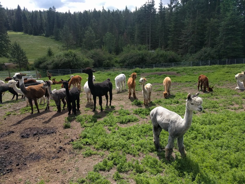
The ride is short enough that you could pick up your rental car right away and head out of town. Or you could spend the night at one of the many hotels in Coeur d’Alene. One night in Coeur d’Alene is just about enough. If you do have some free time, you could visit the Seven Stars Alpaca Ranch or the Silverwood Theme Park. I did both before heading out of town.
Route
Today’s route starts on the Newport to Bayview section of the Bicycling Map. Shortly after turning onto ID-54 E, the route departs from the map in order to get you back to Coeur d’Alene.
Starting on ID-54 E heading east:
- R N Ramsey Rd
- Continue onto W Brunner Rd
- R N Bench Rd/N Ramsey Rd
- Continue to follow N Ramsey Rd
- L W Lancaster Rd
- R N Warren St
- L W Wyoming Ave
- R US-95 S
- follow into Coeur d’Alene